The Vintage News
Feb 22, 2018 Stefan Andrews

Thick canopies of trees making up the jungles of Guatemala have successfully hidden an overwhelming number of lost Mayan ruins, so many that archaeologists are suddenly looking at a real ancient “megalopolis.” Experts have been able to see the full extent of the ruins only now–they have applied novel digital technology to scan an area of more than 770 square miles. The findings have significantly boosted the exploration efforts in the Maya Biosphere Reserve in the northern Guatemala region of Petén.
The novel technology called LiDAR, short for Light Detection and Ranging, has helped experts generate digital maps of the terrain. While flying over the jungle area, the technology has been able to laser scan the terrain below, helping obtain a clear 3D map with the thick tree canopy omitted from it. The recent survey of the area has been only the first phase of a three-year-long project. Some archaeologists have dubbed the new laser technology “magic,” as it helps them realize how big, sophisticated, and advanced the Maya people actually were. It’s unlike anything previously thought.
The digital imagery produced by LiDAR has shown archaeologists spectacular traces of where once, more than 12 centuries ago, Maya society flourished. The evidence of over 60,000 structures that resurfaced with the terrain surveying is compelling proof that Central America was the homeland of an ancient civilization much more sophisticated than previously believed, not the least significant if compared to other ancient civilizations, such as the Ancient Greeks for example.
Besides dwellings and houses, the structures revealed also include highways that connected urban areas with quarries and possibly supported heavy traffic. Archaeologists have been particularly surprised by the evidence of elaborate fortifications, but also farms, which they say would have provided massive amounts of food. Previous considerations had been that the Maya counted up to about 5 million in number; after this discovery, re-calculation and new estimates are inevitable. Experts now raise the numbers to 10 or perhaps even 15 million, many of whom would have lived in areas that were previously considered unlivable.

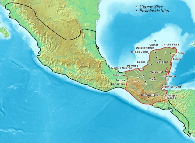
The Maya area within Mesoamerica Kmusser -Photo: Foster, Lynn. CC BY-SA 3.0
For archaeologists who have dedicated their scholarly efforts to studying the Maya people, the outcomes of the project have been something they couldn’t have imagined before. “I think this is one of the greatest advances in over 150 years of Maya archaeology,” commented Stephen Houston from Brown University, a professor of archaeology who has dedicated a career in researching the Mayans. In statements for the BBC, he described the discovery as “breathtaking,” further adding that what he has seen the LiDAR imagery reveal brought tears to his eyes.
Thomas Garrison from the consortium of archaeologists engaged in the latest survey and exploration effort, as well as a specialist for using digital technology in archaeological expeditions, said that “the LiDAR images make it clear that this entire region was a settlement system whose scale and population density had been grossly underestimated,” National Geographic reports.

Zaculeu was capital of the Postclassic Mam kingdom in the Guatemalan Highlands Photo:HJPD CC BY 3.0
While exploration teams have already spent years in attempts to accurately map the landscape in question, only now, after using the scanning technology, they have been able to notice many structures that previously they had missed on seeing.
While the technology has saved years on terrain work and opened eyes to ruins well reclaimed by nature, it also has one problem. According to Garrison, the imagery obtained with it is “an image of 3,000 years of Mayan civilization in the area, compressed.” That is certain to open new challenges for scholars and their attempts to profoundly understand the way of the Maya people.
The earliest Maya settlements have been dated to around 1800 B.C., the start of what has been designated as a pre-classic, formation period of this central American culture. The first period supposedly lasted until some point around 250 A.D., by which time the Maya would have mastery of agriculture, and building stone monuments and pyramid structures. The peak of their civilization followed, in between the third and ninth centuries A.D., time enough to leave lasting proof to the world that great ancient peoples were capable of thriving in terrains noted for harsh weather conditions such is the case with the tropical rainforest environment.

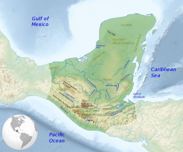
Maximum extent of the Maya civilization. Photo: Simon Burchell -CC BY-SA 4.0
The latest findings only back up evidence of their greatness, how well-connected were different areas where Maya people lived. The roads they had were wide enough to support crowds of people moving, and also elevated to enable regular use even during heavy rainy seasons. The food produced would have likely equaled industrial production as achieved in some modern-day societies, experts further comment.
What caused the Maya to disappear is unclear, though several theories have been proposed in the past such as overpopulation or perhaps a continual state of inter-wars between Mayans themselves. Maybe some of the new data retrieved will help archaeologists ultimately answer this question too.

